TNA Actions

This TNA addresses the challenge of interoperability in data exchange between heterogeneous assets which is currently one of the main bottlenecks for the development of effective cooperative underwater acoustic networks.
This TNA focuses on the design, implementation, and experimental evaluation of a Channel State Information (CSI) acquisition scheme for adaptive underwater acoustic communications.
Visit and recover seafloor observatories (with a ROV) previously “blindly” placed (2016 and 2018) at the plate boundary fault between the African and Eurasian plates, specifically in the portion in the easternmost Atlantic and Alboran Sea. Inspection (HD cameras), study (in-situ measurements) and sample (push cores, discrete seafloor samples) the nearby region in order to link environmental data to the long-term data sets is also intended.
This TNA proposes to use the NATO STO T-LOON testbed, extended with additional assets (additional nodes), to test and validate JANUS enabled networks, as well as JANUS networks applications.
This proposal aims at taking advantage of cooperative sensing strategy using multiple AUVs working as a group, by using a particle filter algorithm for Terrain-Aided Navigation (TAN) in the case where distributed sensing over two vehicles is available and tackle two specific cases that are labeled opportunistic and cooperative TAN. The main objective of the 63 project is to experimentally assess the performance of the algorithms developed for opportunistic and cooperative TAN with two AUVs. A third vehicle, operating as an ASV and equipped with an USBL system and RTK GPS, will measure the positions of the AUVs for ground-truthing purposes.
Run an adaptation of a Gaussian Process (GP) algorithm developed by NTNU for tracking 3D Chlorophyll for UPORTO’s LAUVs to track Salinity instead. The main idea was to do a field campaign at the Douro river mouth to test the algorithm to track the salinity front produced between low salinity water (river) and high salinity water (sea).
Develop novel algorithms required to deploy AUV networks with resource and localization constraints. More specifically tractable approximation and exact algorithms for beacon placement and path planning of AUVs.
The project aims to develop a new method that detects, diagnoses and notifies the occurrence of faults on autonomous underwater vehicles (AUVs) via domain adaptation and transfer learning. The project outcomes will help increase the reliability of these platforms, thus contributing to the assurance of the operations of unmanned marine systems (UMS).
The objective of this proposal is to field test a novel sensor, a differential pressure based speedometer (DPSS) for measuring robots speed and for measuring turbulence.
The objective of the experiment is use of ULaval subsea LiDAR integrated into the NTNU REMUS 100 Arctic AUV to map macroalgae in the Trondheimfjord, setting the stage for future under ice-deployments.
This project focuses on an adaptive habitat mapping in a fjord using heterogenous robotic platforms.
This work is about the analysis and design of tidal turbines that can be installed in situ, or very close to the operational site, to quickly recharge autonomous underwater vehicles. The resources were used to run time domain and frequency domain computational fluid dynamic computations about nominal configurations, to design and implement systems for in situ recharging.
The objective of this project is to develop a reliable and cost-effective surface system to localize and track multiple underwater targets to provide the latter with navigational aid and/or follow their state of progress as a mission unfolds, using a maximum of 2 autonomous surface vehicles (ASVs) equipped with acoustic-based range measuring devices.
This TNA aims at evaluating the performance of underwater acoustic networking methods implemented as part of a EvoLogics modem’s software in shallow water and in different scenarios provided by the NATO STO T-LOON testbed.
The project set out to acquire a remotely-sensed datasets of video and photos in the shallow marine environment beneath cliffs on Inishmore (Aran Islands, Ireland). The primary locations for survey in the waters underneath 2 of Europe’s most important prehistoric monuments: the Bronze-Age forts of Dún Aonghasa and Dún Dúchathair. The focus will be on collection of video datasets, multibeam data and photogrammetry datasets. This cross-cutting project seeks to address questions in coastal geoscience and archaeology and will look at useability of new advanced robotic technology for these operations. The work unites robotics experts from the University of Limerick with geoscientists from Williams College (USA).
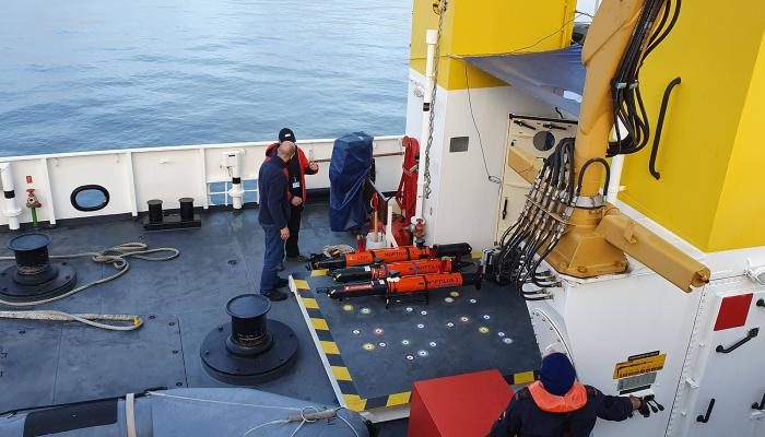
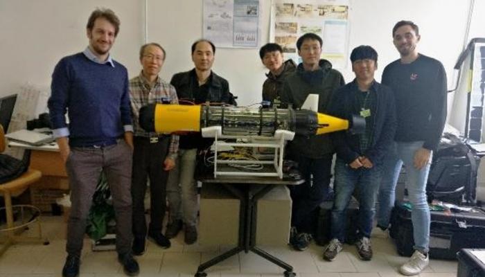
The aims of ECOGLIDER are to capitalize on recent developments and methodologies in sensing and robotic technologies to demonstrate potential services for marine activities needing advanced observations in the Arctic Ocean. Two sensing technologies from the end-user were added to the underwater glider at NOC: real-time passive acoustic monitoring and scientific echosounding. After the technical integration was finalized and tested in the lab, the glider was sent to the NOC research cruise, which took place between 18 June 2021 and 29 July 2021, along the shelf and deep ocean west of Ireland.
The project is concerned with the survey of marl lakes which support endangered crayfish habitats. Specific targets were to (a) acquire topography datasets (b) mapping of surface sediment type (c) assessment of submerged vegetation and (d) acquisition of video and photogrammetry datasets. Additionally, the TNA operations would inform on the effectiveness of data collection and survey techniques in comparison to conventional survey methods like trapping for large benthic crustaceans in lakes.
Test and deploy a path integration system for navigation of AUV based on a newly discovered type of neuron in deep neural networks using the facility provided
This TNA aims at providing support and service to the futuristic applications in underwater acoustic networks with different Quality of Service (QoS) requirements. It investigates novel communication and cross-layering solutions to combat various underwater acoustic challenges by using reconfigurable algorithms employed in software-defined acoustic modems.
This project consists of several parts. The first one is to repeat the experiments of the previous TNA with Toulon University with a high accuracy camera system to have a more precise location of the AUV than when using dead-reckoning navigation. The second part consists in two different methods of cable management for cabled vehicles, and the third is focused on locating an acoustic reflector.
This TNA is focused on simulating vehicle faults (thrusters, sensors, etc.) on the real AUV and reacting safely to them. It also focuses on autonomous exploration. The TNA started in November 2020 with several meetings to discuss the simulation of faults and how to integrate them in the software architecture of the vehicle. Several modifications were done to the Sparus II AUV to add a downward looking camera and a forward looking multibeam. The faults simulated during the experiments are related to percentages of failure in the thrusters that are triggered mid-experiment.
This TNA project builds upon recent research accomplishments in the area of human-robot interaction underwater, by introducing wearable sensors in a form of a diver glove for controlling an autonomous underwater vehicle that serves as a robotic diving buddy.
- The proof of technology for predicting hydrocarbon presence using sea bottom samples as a general objective - Operational evolution going from a protected shallow water test scenario towards a more realistic open water scenario - The test of low power transducer for environmental measurements on the ocean bottom and in the vertical water column.
This TNA proposes to use the NATO STO T-LOON testbed, extended with additional assets (additional nodes), to test and validate JANUS enabled networks, as well as JANUS networks applications.
Localization Approaches for Underwater Autonomy
To study mesoscale structures, such as gyres or eddies, that are formed in the south of the island and the impact they have on the primary production of phytoplankton.
Provide University of Toulon scientists with access to the necessary state of the art infrastructures enabling them to realise experimentations in order to estimate the hydrodynamic parameters of an AUV
To develop a model to simulate the behaviour of an autonomous submarine glider when in operation
The main objective of 3DHAB consisted of the detailed mapping and characterization of the vertical seafloor habitats hosting cold-water corals (CWCs) in Blanes Canyon (NW Mediterranean), using the mapping tools offered by the hybrid remotely operated vehicle (HROV) Ariane. This task was part of the research activities planned to be conducted onboard the R/V Sarmiento de Gamboa, linked to the ongoing Spanish project ABRIC (Assessment of Bottom‐trawling Resuspension Impacts in deep benthic Communities), led by the Principal Investigator who submitted this TNA proposal.
Develop and experimentally validate novel multi-AUV coverage algorithms that can handle currents and faults in the missions.
The goal of this TNA focused on the “Investigation and experimental activities aimed at developing an AUV for Liquid-Argon Time Projection Chambers” is twofold. First part of the TNA is more characterized as activity of education nature that is preparatory for a full fruition of the second, applicative, part that includes experiences on ISME AUVs at SEALab infrastructure.
Test the coordinated mission control of heterogeneous ASVs in a convenient and remote way by adopting cloud-based technology
The TNA will provide an experimental validation and demonstration of low cost, miniature acoustic transceivers providing a flexible multi-user positioning framework to support AUV and diver operations.
The Norwegian start-up company ECOTONE has developed a unique hyperspectral underwater camera. Hyperspectral images allow to record the reflectivity of the scene as a function of the optical wavelength. The resulting imaging data allows to gain information on the nature of the seafloor. For ocean science, this technique provides huge potential for automatic classification of substrates and biosphere of the sea-bottom environment.
Benchmarking, in an operational setting, the use of teams of autonomous underwater vehicles to improve the oceanographic data collection while reducing the logistical overhead for the human element.
Detect and map seabed seepages in the Levant Bay, Vulcano. In the context of the Marine Geosciences and Marine Robotics Summer School.